Wednesday, December 15, 2010

Comida de Colombia

In Colombia, the food is simple, cheap, and delicious. Colombians eat a lot of rice, beans, soups, and corn-based foods. They have tons of fruit, including some that we've never heard of because they're unique to that part of the world.

El Plato del Dia

Typical Plate of the Day

Most restaurants have a "Plate of the Day" for lunch and dinner that includes soup, a meat, beans, rice, a small salad, a fried plantain, an arepa, and a glass of juice. All for about $4 or less.

Chocolate and Cheese

Have a hunk of cheese with your hot chocolate.

Colombians love their chocolate and cheese. Together. We didn't believe it either until we saw it. They cut up the cheese and drop it into the hot chocolate. Sounds strange, but it is popular for breakfast or a snack.

Arepa

Arepa con Queso

Arepas are everywhere in Colombia. They can be made of either yellow or white corn. They often have no filling but we preferred them with hot gooey cheese in the middle. They generally come with a meal, sort of like a dinner roll, but they are popular for breakfast as well. We discovered the arepa at the beginning of day one and it became one of our staples for the entire trip.

Fruit and Juices

Plantain soup and papaya juice.

Colombia grows a lot of delicious fruit and they are able to grow it all year round because of the favorable climate. They have some interesting fruits we had never heard of, like the lulo, a tart fruit that looks like an orange on the outside but is green on the inside. Juices are very popular and we had tasty blackberry, papaya, tomato, and strawberry juices. All very fresh and with no sugar added!

Coffee

Coffee Plant

A lot of coffee is grown in Colombia and since we spent most of our time in Eje Cafetero, the coffee region, we certainly drank our share of it. We toured a coffee plantation in Salento and learned about the different types of coffee and the coffee making process.

Saturday, December 4, 2010

In and Around Manizales

Thermal Springs of Santa Rosa de Cabal

On our way to Manizales from Salento we stopped at the Termales de Santa Rosa. The hot pools are set amid lush green scenery at the base of three waterfalls. We relaxed in the hot water for a while and took a short hiking trail up over the springs to get a better view of the big waterfall.


Thermal pools and the crashing waterfall above.


Swiss chalet style hotel built around the thermal springs.

We took a chiva back to Santa Rosa. A chiva is a colorful bus characteristic of Colombia and Equador and has become a symbol of Colombian culture. The roof is used to carry bags, fruit, and whatever else people might be transporting. We were the first ones on but by the time we go to town, it was packed with people.


Manizales

Manizales is a college town and one of the larger cities of the coffee region. It is built on a ridge. The main thoroughfare of the city runs along the top of the ridge and the cross streets slope down sharply on either side of the main street. Like everything else in this part of the country, it is surrounded by green hills.

Backroads of Manizales


View from an overlook.


Hilly farmland outside of Manizales.

Sunday, November 28, 2010

Salento and the Valle de Cocora

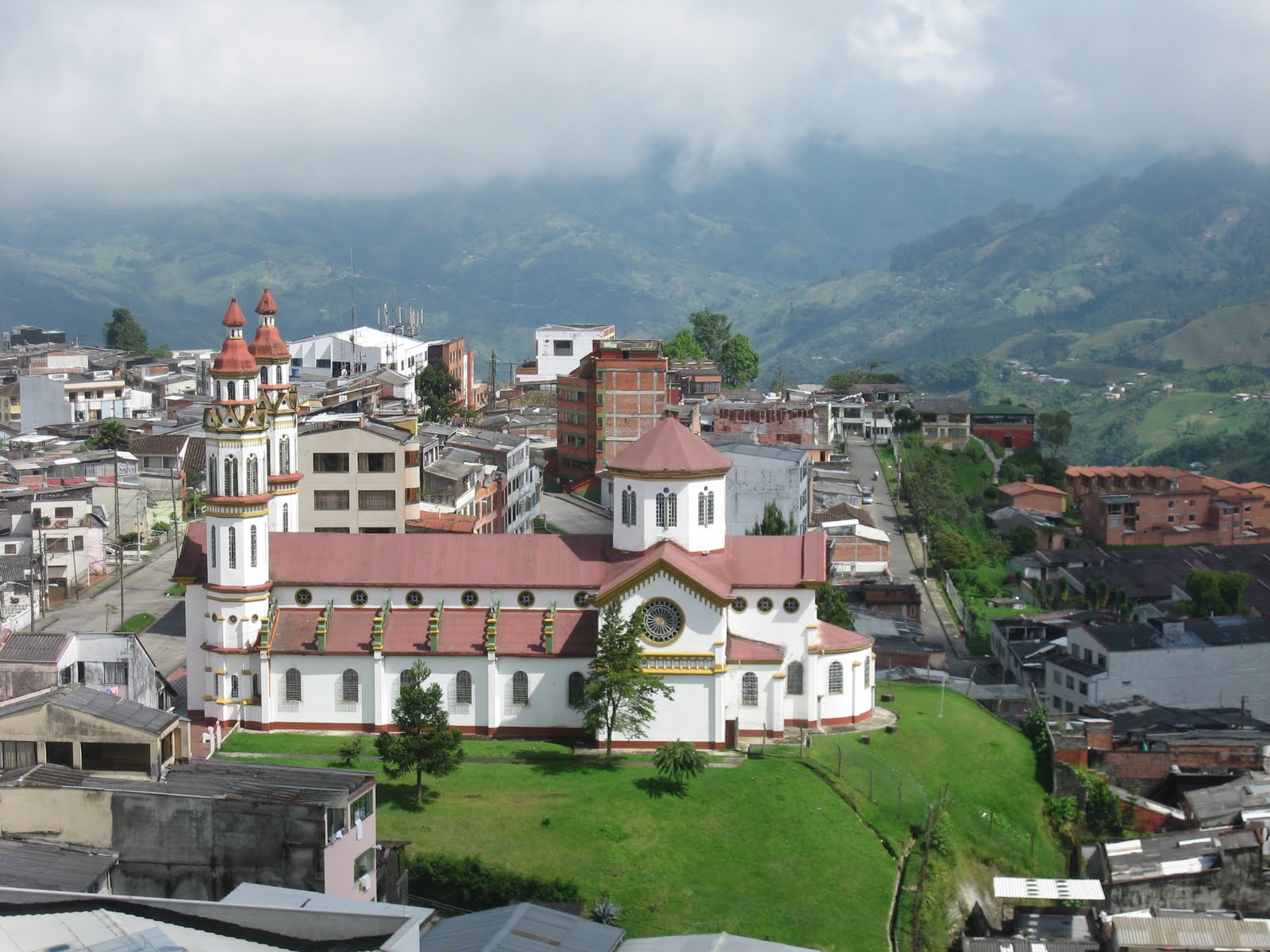
The Eje Cafetero (Coffee Axle) is the central Andean region of Colombia that produces the majority of the country's coffee. It is lush area full of green hills that look so, well, Colombian. We chose this area as the major destination for our trip because we had read so much about the region's natural beauty.

View from the bus while speeding over the Andes Mountains from Bogota.


Salento


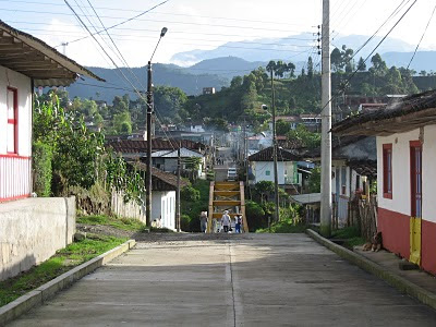
Salento, the tiny but adorable town we stayed in for a few days, is a real gem. The people are kind and the streets are safe enough for kids to roam around after dark. Buses take people to the bigger cities of Armenia and Pereira but the best way to get around town is by jeep (basically the town's taxi system) or motorcycle. Farms, mountains, and lush landscape surround the town on all sides.

Valle de Cocora

Valle de Cocora and the classic wax palms.

The Valle de Cocora is is a valley located just a short drive from Salento. This picturesque landscape is full of wax palms, the tall skinny palm trees that are the national tree of Colombia. We arrived in the town square for our 7:30 a.m. departure and loaded up into several jeeps with other travelers for the ride out to the valley. It rains regularly here and the ground was extremely muddy.

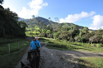
Normally we enjoy hiking on foot, but we decided to try horseback riding for half of the hiking loop. We had a guide (who was interestingly on foot rather than on a horse). He walked behind us the whole time, making whistling and clicking noises the whole time that somehow guided the horses.

Randy the Horseman

The horses were good sports, crossing rivers and ascending steep mountain trails. Randy's horse got stuck in the knee-deep mud and nearly bucked him off when he tried to get out. A nearby Australian tourist commented on Randy's impressive horsemanship.


The Quindo River runs through the valley. The beautiful valley has farms on either side where cows graze. As the trail went up into the mountain, the landscape changed into a dense forest. At the top, we entered a nature reserve where an older couple runs a little camp and serves snacks to hikers. Once we got really high up, we were in the clouds.

The "cloud forest" needs no further explanation.

The area has wonderful trout. We had one of our best meals of the whole trip at Rincon de Lucy. It was delicious and marvelously cheap. The meal included soup, a banana, locally grown trout, rice, beans, vegetables, and blackberry juice.

All this food for two for just $6!

Wednesday, October 20, 2010

Rainy Switzerland

Lucerne from above.

Andrea has a long history of crashing her parents anniversary. In fact, she was born on their second anniversary! So it was only fitting that we would join them for one weekend of their two-week 30th Anniversary trip to Europe.

We joined the 'rents in Zurich and followed them to Lucerne, spending one night in each city. Despite the fact that it rained a good portion of the time, we had a really fun time!

Nothing fills a tummy like Germany food!

The creepy thing about Switzerland is that everything is perfect. Well, okay not the weather. And the prices are a bit high. But everything else - the perfectly painted houses sitting perfectly on the hillsides, the chocolates in perfect shapes that melt in your mouth, the swans swimming perfectly into your pictures, and you get the point. It really is like the best parts of Heidi and The Sound of Music, all rolled into one.

The Swiss bring chocolate truffles to a whole new level.


The attractive riverfront of Lucerne.

Expensive, yes. Rainy, yes. But if you can get past a few rainy days rainy days a year, okay make that more like 100, Switzerland is a really dreamy place with storybook scenery, quality restaurants, and really great window shopping.

Wednesday, September 15, 2010

The Great Unknown in Our Own Backyard

When we moved to Queens three years ago, we though we were moving to Long Island. It's a simple mistake that any person holding a map can make.

But any New Yorker or Long Islander can tell you that Queens, although geographically located on an island called Long Island, is really a world away from that which is referred to as "Long Island". There is no official border crossing between the two and no passport is necessary. Even so, people are pretty good about sticking to their respective sides and few see reason to cross the invisible barrier. Legend has it that some people live their whole lives in either Queens or Long Island without ever stepping foot inside the other.

All this helps explain why taking a day trip to Long Island, the other side of the very island we live on, was a journey into the great unknown.

So we probably would have continued to live our Queenly existence without giving one thought as to what lies on the other side of the Cross Island Parkway if it weren't for a few good friends who decided to treat us to a cultural experience. We were quickly lured in by promises of trees, open land, and houses with their own yards.

Our friends don't mess around. They drove us clear across Long Island and all the way to the North Fork, a scenic area with beaches and wineries. At 118 miles from one side to the other, the island certainly lives up to it's name.

Inside our first winery - ever!

We're more familiar with apple-picking than grape-squashing. But we very much enjoyed a pleasant and relaxing afternoon visiting three vineyards.

Attractive wine display at Pindar Vineyards.

At Shinn Vineyards, Scott kindly lent his wine glass as a model for Randy's photography shoot. It sparkled in the late afternoon sun like a diamond engagement ring!


The last stop of the day was the city of Greenport. This charming coastal town has a lovely marina, adorable shops, and seafood restaurants. It felt like vacation (even if it only lasted for a few hours).

You think we can afford one of these boats if we all pitch in?

Besides seeing the beautiful vineyards, we picked up on all kinds of new vocabulary, like "North Shore" and "Robert Moses" as well as hard to pronounce words like "Cutchogue". Without this fun day trip, we never would have known how the North Fork was different from the South Fork, or that the island even forked at all for that matter.


Thanks to our good friends the Bowdens (left) and the Risingers (real life Long Island natives!!) for a fun, educational, and culturally rich experience.

Sunday, July 18, 2010

The Great Outdoors

For the 4th of July, we visited Andrea's brother Matt, who moved to Wyoming earlier this year. We had never been to this part of the country so we jumped at the chance to breath fresh air and see wide open spaces and stars in the sky.

Our domestic travels rarely take us past the east coast, so this was a good opportunity to visit the wild, wild, west and even hit up a few national parks. Since Andrea's dad was going, it was a mini family reunion as well (minus mom).

We're a hiking family and quickly embraced the beautiful trails and scenery of Grand Teton National Park.


We went to Yellowstone too. The hiking wasn't as good as in the Grand Tetons, but we saw buffalo, geysers, and waterfalls.

Standing above a canyon at Yellowstone.

We stayed at a lodge on Jackson Lake, just outside of Jackson. The view of the Tetons was stunning from here and the sun hit the mountain peaks beautifully each morning.


For two New Yorkers, Wyoming might as well be Pluto. It's vast, unpopulated, and has all kinds of dangerous animals, like grizzly bears, buffalo, and other large mammals that a city kid couldn't be expected to identify. Luckily, we had Matt to guide us, who in six short months has practically become a John Wayne.

The guys on a raft on Snake River.

Our hiking endeavors used up a lot of calories. Since dad was there, we were fueled by a steady stream of red meat, cheez-its, and various desserts.


Thanks Matt and Dad for a great trip!

Monday, May 24, 2010

Desert Adventures


"After Saul returned from pursuing the Philistines, he was told,
'David is in the Desert of Ein Gedi.'" - 1 Samuel 24:1

Our last stop in Israel was the Ein Gedi Nature Reserve at the Dead Sea. We took a bus from Jerusalem and stayed at a field school that conducts environmental projects in the area but also has rooms to accommodate travelers.

Ein Gedi is mentioned in the Old Testament of the Bible as the place where David hid from Saul. It is an oasis in the middle of the Judean Desert fed by two rivers and two springs. It was first inhabited in the Stone Age.

It was dark when we arrived close to midnight so we couldn't tell what was around us until the next morning. We were surprised to walk out of our room just after 7 am to blaring sunshine, a beautiful blue strip of water, and tall sandy peaks.

We grabbed our hiking map and set off for Mount Yishai, located right behind the field school. The trail was steep and rocky but it only took about 1 hour to reach the top. From there, we could look out across the desert plateau to the east and the Dead Sea and Moabite Mountains in Jordan to the west. We hiked around a canyon and down into the oasis where there is a river, waterfalls, and pools.

Summit of Mount Yishai


Is that Mr. and Mrs. Yasser Arafat?

We donned Bedouin-style headdresses to protect ourselves from the harsh desert sun. The fashion style of the Middle East sure makes a lot of sense once you're there.

Finally, we find the oasis!

After hiking for six hours we enjoyed a swim, or rather a float, in the Dead Sea. The Dead Sea is bordered by the West Bank to the north, Israel to the south, and Jordan to the East. The surface is 1385 feet below sea level and contains high levels of bromine, magnesium, and iodine.

Floating in the Dead Sea

You don't have to worry about anything biting you because virtually nothing can survive in this salty environment. Because of the high density of the water, people float! It's actually hard to swim because of the way your body bobs to the top.

If it was good enough for Cleopatra, it's good enough for us.

Black mud from the Dead Sea, which smells like sulfur, is supposed to be rich in minerals and therefore good for your skin. You can buy in online for a lot of money, or just come to the Dead Sea and stick your hand in a hole and grab a handful.

Saturday, May 22, 2010

City Views

Mount of Olives

We started the day waking up at 5 am to go to the top of the Mount of Olives and catch the early morning light on the city of Jerusalem. We took a bus up to the mount and before we saw the view, we practically ran into a camel, who was just hanging out in the middle of the road alone eating trash.

Randy and the camel


Jerusalem

The overlook at the top of the mount is one of the best views of Jerusalem. There is a huge Jewish cemetery on the side of the hill with approximately 150,000 Jews buried there. It is the oldest continually used cemetery in the world. There are several churches on the mount and the Garden of Gethsemane is located at the bottom.

Jewish Cemetery on the Mount of Olives

The last thing we did before leaving Jerusalem was one of the best. We bought tickets to go up onto the top of the wall that surrounds the city. You can walk around the whole city and see everything from above.

On top of the city wall.

Friday, May 21, 2010

Bethlehem

Manger Square in Bethlehem

Today we took a day trip to Bethlehem. This was our first visit to a Palestinian-controlled city and we weren't sure what to expect. Getting there was easy enough - our bus drove us straight through the checkpoints and into the city. Returning to Jerusalem, we had to take a cab to the checkpoint just outside of town, walk through a security checkpoint to have our bags scanned and show our passports, and catch a bus on the other side.

The controversial wall Israel is building between Israel and the Palestinian Territory.

The city is famous for being the birthplace of Jesus, making it a popular place for tourists and pilgrims. The biggest attraction is the Church of the Nativity, built on the sight where Jesus was thought to have been born. Commissioned in AD 326, it is the oldest continually operating church.

The star on the floor marks the birthplace of Jesus.

Like everything else in this part of the world, the church has seen its share of drama. The management of the church is currently shared by three groups - Greek Orthodox, Armenians, and Catholics - who don't get along.

The city is majority Muslim, although it is also home to a large group of Arab Christians. We happened to go on a Friday, which is the Muslim prayer day, so most of the shops and businesses were closed.

Muslim men gathered in Manger Square to hear the Friday midday prayer broadcast over loudspeakers from the nearby mosque.

We returned to Jerusalem in time for another visit to the Western Wall for Shabbat. Shabbat is the Jewish day of rest and begins at sundown on Friday and ends on Saturday night. No work is permitted on Shabbat including writing, taking pictures, turning lights on or off, or using a cell phone. The beginning of Shabbat is a very popular time to go to the Western Wall and pray. Everyone dresses up in nice clothes. The whole area around the wall was packed with people.

This photo of the Western Wall was taken before Shabbat began since we were not permitted to take pictures after it started.